


وصف لـ MyRadar Weather Radar
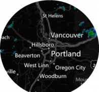
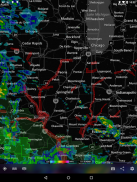
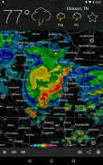
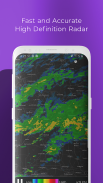
MyRadar is a fast, easy-to-use, yet powerful weather app that displays animated weather radar around your current location, allowing you to quickly see what weather is coming your way. Just start the app, and your location pops up with animated live radar, with radar loop lengths of up to two hours. This basic functionality provides the quickest way to get a fast snapshot of the weather on-the-go, and it's what has made MyRadar so successful over the years. Check your phone and get an instant assessment of the weather that will impact your day.
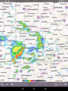
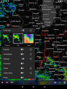
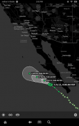
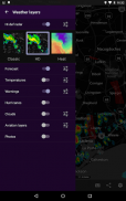
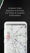
In addition to the live radar, MyRadar has an ever-increasing list of weather and environmentally-related data layers that you can overlay on top of the map; our animated winds layer shows a breathtaking visual representation of both surface winds and winds at the jetstream level; the frontal boundaries layer shows high and low pressure systems as well as frontal boundaries themselves; the earthquakes layer is a great way to stay on top of the latest reports on seismic activity, completely customizable as to severity and time; our hurricane layer allows users to stay on top of the latest tropical storm and hurricane activity throughout the world; the aviation layer overlays AIRMETs, SIGMETs and other aviation-related data, including the ability to track flights and display their IFR flight plans and paths, and the "wildfires" layer allows users to stay abreast of the latest fire activity around the United States.
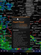
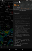
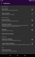
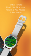
In addition to the data layers, MyRadar has the ability to send weather and environmental alerts, including alerts from the National Weather Center, such as Tornado and Severe Weather alerts. A new feature introduced in this version of MyRadar includes the ability to receive alerts based off of Tropical Storm and Hurricane activity; you can configure the app to send you an alert any time a tropical storm or hurricane forms, or is upgraded or downgraded.
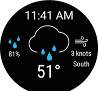
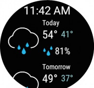
One of the most useful features in MyRadar is the ability to provide advanced rain alerts; our patent-pending process for predicting hyper-local rainfall is the most accurate in the industry. Instead of having to check the app all the time, MyRadar will send you an alert up to an hour in advance as to when the rain will arrive at your current location, down to the minute, including details on intensity and duration. These alerts can be a life saver when you're on-the-go and don't always have time to check the weather - our systems will proactively do the work for you and let you know in advance before the rain hits.
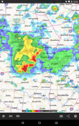
All of the weather and environmental data represented on MyRadar is displayed on our custom mapping system, developed in-house. This mapping system uses your devices GPU, which makes it incredibly fast and speedy. When you're looking for quick weather information on-the-go, that makes a huge difference. The map has the standard pinch/zoom capability which allows you to smoothly zoom and pan around the United States and the rest of the world to see what the weather is like anywhere on the planet.
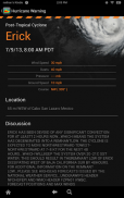
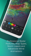
In addition to the free features of the app, a few additional upgrades are available, including real-time hurricane tracking - great for the start of hurricane season. The hurricane tracker provides additional data above and beyond the free version, including the cone of probability for tropical storm/hurricane forecast tracks, and it also includes a detailed synopsis from the National Hurricane Center. The premium upgrades also include the professional radar pack, which allows greater detail of radar from individual stations. Users can select individual radar stations around the US, select the radar tilt angle, and also change the radar product being displayed, including base reflectivity and wind velocity - great for experienced weather buffs looks to stay on top of possible tornado formation.
Don't get caught off guard with bad weather; download MyRadar today and try it out!
MyRadar هو تطبيق طقس سريع وسهل الاستخدام وقوي يعرض رادار الطقس المتحرك حول موقعك الحالي ، مما يتيح لك رؤية الطقس بسرعة في طريقك. ما عليك سوى بدء تشغيل التطبيق ، وينبثق موقعك من خلال رادار حي متحرك ، بأطوال حلقة الرادار تصل إلى ساعتين. توفر هذه الوظيفة الأساسية أسرع طريقة للحصول على لقطة سريعة للطقس أثناء التنقل ، وهو ما جعل MyRadar ناجحًا للغاية على مر السنين. تحقق من هاتفك واحصل على تقييم فوري للطقس الذي سيؤثر على يومك.
بالإضافة إلى الرادار المباشر ، لدى MyRadar قائمة متزايدة من طبقات البيانات المتعلقة بالطقس والبيئية والتي يمكنك تراكبها أعلى الخريطة ؛ تظهر طبقة الرياح المتحركة الخاصة بنا تمثيلًا مرئيًا رائعًا لكل من الرياح السطحية والرياح على مستوى jetstream ؛ تُظهر طبقة الحدود الأمامية أنظمة الضغط العالي والمنخفض وكذلك الحدود الأمامية نفسها ؛ طبقة الزلازل هي وسيلة رائعة للبقاء على رأس آخر التقارير عن النشاط الزلزالي ، قابلة للتخصيص تمامًا من حيث الشدة والوقت ؛ تسمح طبقة الإعصار الخاصة بنا للمستخدمين بالبقاء على قمة أحدث أنشطة العواصف المدارية والأعاصير في جميع أنحاء العالم ؛ تراكب طبقة الطيران AIRMETs و SIGMETs وغيرها من البيانات المتعلقة بالطيران ، بما في ذلك القدرة على تتبع الرحلات الجوية وعرض خطط ومسارات رحلة IFR الخاصة بها ، وطبقة "حرائق الغابات" تتيح للمستخدمين البقاء على اطلاع على أحدث أنشطة الحرائق حول الولايات المتحدة.
بالإضافة إلى طبقات البيانات ، لدى MyRadar القدرة على إرسال تنبيهات الطقس والبيئة ، بما في ذلك التنبيهات من National Weather Center ، مثل Tornado و Severe Weather. تتضمن ميزة جديدة مقدمة في هذا الإصدار من MyRadar إمكانية تلقي تنبيهات تستند إلى نشاط Tropical Storm و Hurricane ؛ يمكنك تكوين التطبيق لإرسال تنبيه إليك في أي وقت تتشكل فيه عاصفة مدارية أو إعصار ، أو تتم ترقيته أو خفضه.
واحدة من أكثر الميزات المفيدة في MyRadar هي القدرة على توفير تنبيهات المطر المتقدمة. إن عملية انتظار براءات الاختراع الخاصة بنا للتنبؤ بهطول الأمطار في المناطق المحلية هي الأكثر دقة في الصناعة. بدلاً من الاضطرار إلى التحقق من التطبيق في كل وقت ، سيرسل لك MyRadar تنبيهًا قبل ساعة من موعد وصول المطر إلى موقعك الحالي ، وصولاً إلى الدقيقة ، بما في ذلك تفاصيل عن شدته ومدته. يمكن أن تكون هذه التنبيهات منقذة للحياة عندما تكون قيد التنقل ولا يتوفر لديك دائمًا الوقت للتحقق من الطقس - ستقوم أنظمتنا بالعمل نيابة عنك وتتيح لك معرفة ذلك مسبقًا قبل هطول الأمطار.
يتم عرض جميع البيانات المتعلقة بالطقس والبيئية الممثلة في MyRadar على نظام رسم الخرائط المخصص لدينا ، الذي تم تطويره داخل الشركة. يستخدم نظام التعيين هذا GPU للأجهزة ، مما يجعله سريعًا وسريعًا بشكل لا يصدق. عندما تبحث عن معلومات الطقس السريعة أثناء التنقل ، فإن ذلك يحدث فرقًا كبيرًا. تحتوي الخريطة على القدرة القياسية للقرص / التكبير والتي تتيح لك التكبير والتصغير بسلاسة في جميع أنحاء الولايات المتحدة وبقية العالم لمعرفة ما يشبه الطقس في أي مكان على هذا الكوكب.
بالإضافة إلى الميزات المجانية للتطبيق ، تتوفر بعض الترقيات الإضافية ، بما في ذلك تتبع الإعصار في الوقت الفعلي - وهو أمر رائع لبدء موسم الأعاصير. يوفر متعقب الإعصار بيانات إضافية تتجاوز الإصدار المجاني ، بما في ذلك مخروط الاحتمالات للمسارات المتوقعة للعواصف المدارية / الإعصار ، ويتضمن أيضًا ملخصًا تفصيليًا من المركز الوطني للأعاصير. تشمل الترقيات الممتازة أيضًا حزمة الرادار الاحترافية ، والتي تتيح مزيدًا من التفاصيل للرادار من محطات فردية. يمكن للمستخدمين اختيار محطات الرادار الفردية في جميع أنحاء الولايات المتحدة ، وتحديد زاوية إمالة الرادار ، وكذلك تغيير منتج الرادار الذي يتم عرضه ، بما في ذلك قاعدة الانعكاس وسرعة الرياح - وهذا أمر رائع بالنسبة لعشاق الطقس ذوي الخبرة الذين يتطلعون إلى البقاء على رأس تشكيل الإعصار المحتمل.
لا تنزعج من سوء الاحوال الجوية. قم بتنزيل MyRadar اليوم وجربه!
MyRadar Weather Radar - إصدار 8.51.1
(09-12-2023)
MyRadar Weather Radar - معلومات APK
نُسخة APK: 8.51.1الحزمة: com.acmeaom.android.myradarتطبيقات من الفئة نفسها
قد يعجبك أيضًا...


